The magnificent, thrilling trail across the Pin Parvati Pass was first crossed by Sir Louis Dane in August 1884 but still, it is rarely visited. The trail can be accessed from the month of July to September end. Although it is considered as one of the difficult Trans-Himalayan treks, when the offer came I couldn’t resist my greed to walk on such a variegated terrain last September. Besides being a sleep – snatching event it was heightened by the charming company of my co-trekkers.

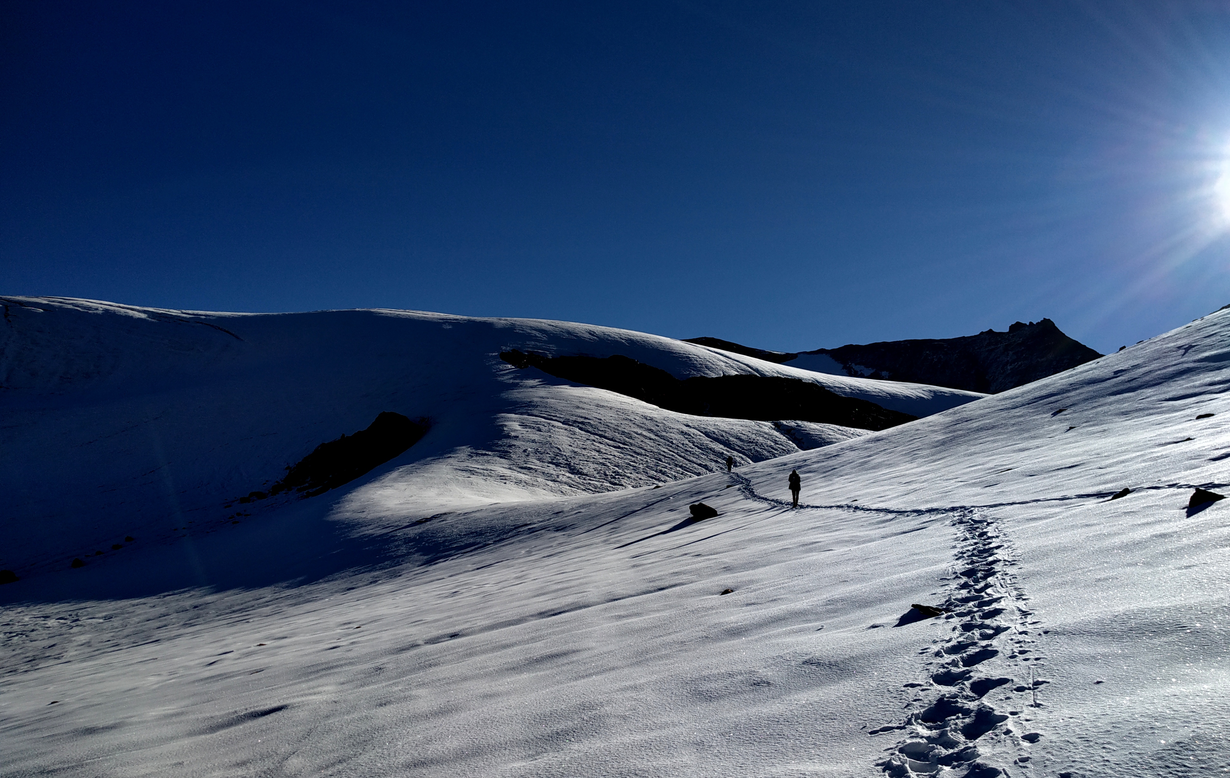
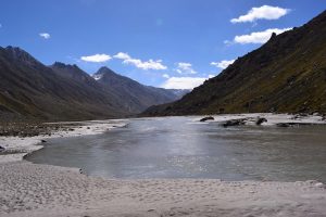
Crevasse-ridden Parvati Valley
People generally start from Bhunter, the confluence of the Beas and the Parvati river but in order to collect some materials we stayed at Manali and it was a thrilling journey I ever had while riding from Chandigarh to Manali in heavy rain. The frequent rainfall was one hell of an experience at Manali.
Manali to Barseni ( 6-7 hours drive ) – Pulga Campsite ( 7068 ft )
It was almost a six hours drive from Manali to Barseni, the confluence of the Parvati river and the Tosh Nala, where the macadamized motorable pavement ends. The peaceful locality includes a hydel power plant established over the flowing Parvati river. In the middle of the ride, the weather condition was improved but again it started to be retrograde which forced us to run to Pulga campsite.
-
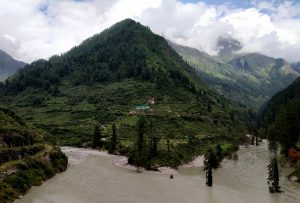
- Confluence of Tosh and Parvati
-
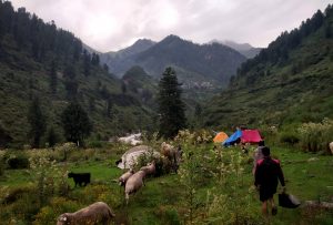
- Pulga Campsite
After a few steps, the asphalted path to Tosh village takes a diversion and descends to a metal bridge crossing the gushing Tosh Nala. The trail to Pulga campsite was totally muddy and feculent due to the continuous movement of sheep in rain. The campsite is quite dampish as it is situated in the midst of an apple forest. People should move carefully because the ground is crowded with thistles and nestles.
Pulga to Kheerganga ( 8950 ft – 13 km – 5-6 hours)
It was a busy morning as there was a need to dry up all the wet clothes and the porters started to pack the luggage according to the weight. At first, the track ascends for a while gradually and then it reaches to the traditional Himachali village, Nakathan 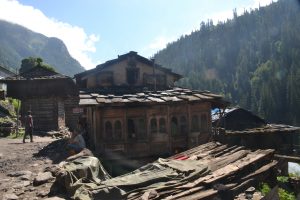 through the alluring apple and pomegranate orchards. There are several establishments for travellers too. After a while, the Rudranag comes and an agitated waterfall strikes the mind. Only a short walk away a tottering bridge crossing the Parvati stream leads the way up. Here the rushing river sounds a boomed mainsail.
 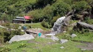 In the midway, we came across a huge but quite serene waterfall over which a dhaba is established in a cluttered way. By relishing the wondrous beauty of the forest, playing hide and seek of the sunshine, the magical movement of clouds we moved on and reached Kheerganga. As described in the mythology, Lord Shiva came here and is said to have meditated for thousands of years. “Kheerganga” means “milky white sacred water” as the hot water spring is considered sacred by the locals. There is a lot of temporary establishments to accommodate hikers. In this context I must tell that this place of magical Himalaya is quite popular for the sacred hot spring and these mountains are quite fertile for the marijuana, hemp etc, even the campsite doesn’t get darkened because of the trail-side huge electronic lamps. The rumbling of river Parvati created a wonderful charming cacophony.
Kheerganga to Tunda Bhuj (10675 ft – 14 Km – 5-6 hours )

Kheerganga Campsite
To avoid the evening shower the wise decision is to leave the campsite early. The trail beside the Shiva temple leads the way to the next campsite having the river Parvati in the left. At first, the track ascends gradually through the towering pines and mighty Rhododendron trees and later on opened up to vast meadows. The footsteps on dry leaves make a hypnotic sound-track like an anklet-tone. Tunda Bhuj is named so maybe because of the innumerable presence of the Bhuj trees in this portion. 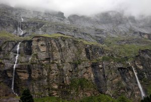 There is no chance of getting out of the water as en route to Tunda Bhuj we crossed two major rivulets and several streamlets. On the trail, a huge flock of sheep may obstruct you occasionally. Before the last ascend there we noticed a waving red flag few humps away. We tried our best to establish the campsite but no, it’s not covered up, the event delayed due to the tremendous sleet-shower. This is a heavenly kingdom of waterfalls. In the morning, the skyscape looked as if buckets of blue paint were outpoured. The wide valley cut by the silvery waterline, peeping of few snowcapped peaks made me fettle.
Tunda Bhuj to Thakur Kuan ( 11350 ft – 11 Km – 4-5 hours )

It was a pulley bridge which was destroyed years ago
The day starts by walking through the meadows first, then few portions through the coniferous forest on the right bank of the boisterous river Parvati. After that, the lust green meadows ended up from where we had to cross a massive landslide being like spiders. The brooks flowing over made the rocks oozy. Gradually the spiral track opened again to a wide valley where the sun kissed the tip of the leaves. The strenuous course called an end at a soapy meadow which was a riot of colours.
Thakur Kuan to Odi Thach ( 11861 ft – 9 Km – 3-4 hours )
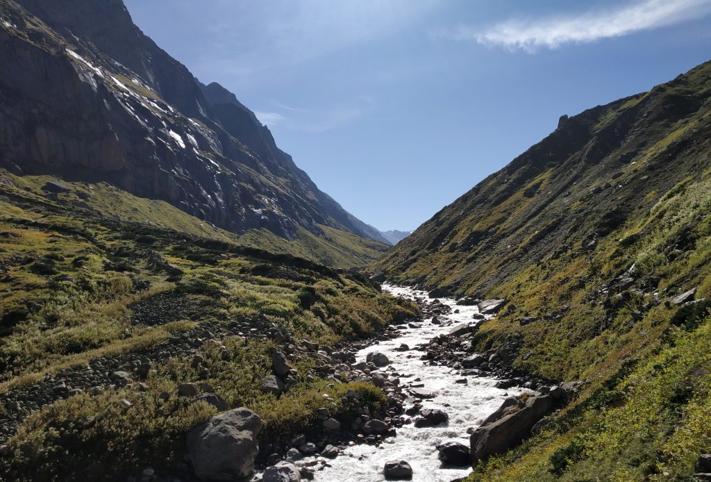
With the dawning sun, the indolence was shaken off fully. The tricky day started with a variety of acclivity and declivity. The riming of the mighty Parvati valley moderately ascends to two natural rock bridges. The smaller one comes first which crosses one wide tributary falling from the right and the huge one, named as Pandu Bridge comes at a distance.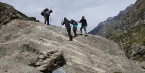 It is said that the bridges are examples of the strengths of the Pandava brothers. When they faltered to cross the turbulent river they took a halt in nearby caves, while in the night dream goddess Kali directed the way. Accordingly, the rocks were put over the river.

Pandu Bridge
Rain may increase the difficulty level to cross the bridges as these become oozy. After crossing the Pandu bridge the track on the left bank of the river Parvati ascends gradually and sometimes it wanders away into the deep, black bushes of Juniper. The wide valley of the upper Parvati is decorated with abundant tiny flowers and rocky outcrops where few species of mushroom can also be found. The wide vale of Odi Thach has several rocky windows from where massive snow-covered mountains peeped in. The flaming sunset scene accompanied by wavy clouds was mind-snatching.
Odi Tach to Mantalai ( 13100 ft – 15 km – 6 hours )
With the movements of clock-hands, bit by bit, the artistic golden sun got up like a baby and started painting the smoky sky into a bright blue one. In such a warm morning I prepared myself for another long stretch to Mantalai, a glacial lake from where gorgeous river Parvati had been initiated.

Odi Thach
Mythology says that Lord Shiva meditated there for years of duration and after that Parvati got pleased and started to flow. Initially, the trail transits through the broad meadows. Tiny but jewel-toned alpine flowers being clustered here and there glamorize the footsteps on the left bank of the river. It was hard to imagine that it’s the same river that can send shivers down the spine at a mere glimpse from the wooden bridge of Rudranag. Pretty straight forward track through a boulder-strewn vale takes to a lagoon called Mini Mantalai, surrounded by the skyrocketing snow-crowned peaks. Here it was noticed that thousands of streams flowing over a vast wide flat land and the mighty Parvati in its embryonic stage.
Later the high altitude marshland led to the final assault, the holy place decorated with coloured flags, the phallus of Shiva came after a steep climb of around 300 meters. There as if the river stopped its howling, almost a profound and breathless silence swallowed the environment. When the moraine track snaked down to the lake, the beauty was seen just beyond the imagination. When the snow-flakes stopped showering, the graceful reflection of numerous towering peaks on the golden ripples in the lake is diligently enveloped in my mind’s ark.
Mantalai to Base Camp ( 15000 ft – 6 Km – 5-6 hours )
The very first portion of the hike includes a walk over huge boulders, expanded smudgy glacial plane forked by thousands of waterline originated from the surrounding snow-capped mountains, the crossing of a wider stream barefooted. It was a steep ascent of almost 800ft and there was hardly a well-defined trail, the trailside boulders were decorated with frozen waterlines of a different shape.
After the first ascent, the bird’s eye view of the glacial plain just dazzled all the senses. While going up through the last but not the least steep moraine track to the base camp, the massive Pyramid Peak, South Parvati Peak was standing behind like an instructor and watching the trekkers gasping. People can capture a spellbinding 360-degree panoramic shot only in the eyes. The place is like basin amidst the rocks and glaciers surrounded by ranges of snowy mountains of Parvati valley.

Base Camp
Base camp to Pin side base camp ( 14150 ft ) via Pin Parvati Pass ( 17400 ft ) – ( 10 Km – 3-4 hours )
Finally, the D-day has come and it is better to start as early as possible. In tremendous excitement besides having nervousness also early in the morning, I was found hustling and bustling with my shoes as those were found frozen stiff. Naturally, it consumed a few more time. Marching was started through an outstretched snowfield. As we pushed ahead facing to the extreme east negotiating hidden or open crevasses and icy slopes carefully, mighty Parvati glacier was found in a call. While walking on the permafrost region numerous snow-capped peaks were seen as the spectator of our live performance. Finally the highest point, Pin Parvati Pass is reached up, the time arrived for which I tormented myself for the last few months.

Pin Parvati Pass
The pass offered a wide panorama of peaks and snow-covered vales of Spiti as well as Parvati. The pristine snow-capped peaks nearby were spotted. The silent stretches of Pin valley with all its grandeur acted as a reward for all the labour. It was a spectacular view of both the valleys with flittering of prayer flags and unnamed peaks populating the sight. The lofty peaks of Kinnaur, Kullu and Spiti made the sight enchanting. Unfortunately, one cannot stay on the summit forever. Going up may be one’s choice but getting down is mandatory. Initially, walking down from the pass was quite comfortable negotiating the wide snowfield. The descend was although gradual but brutally crevasse-ridden and most of the crevasses are hidden. Still, the aligned mountains found some players crossing the hurdles. de-stresses and playing with snowballs in knee-deep snow.
Where the immense ice field had ended, steep, loose scree started. As we were moving down, we were being out of sorts. But according to Andy Andrews, “it is in the valley that we slog through the lush grass and rich soil, learning and becoming what enables us to summit life’s next peak”. Being motivated by this we followed the hefty path on the left bank of the Pin river.

Pin side base camp
Once we reached the Pin valley base camp it was totally another world, it was bare, rocky moon-land below the Pin glacier. It was quite warm and we had to conquer sudden dust breezes. It’s too not possible to stay inside the tent to get rid of getting a dustwrapper as there is unbearable heat inside the tent. There is a wide stream coming from the Pin glacier where people can get freshen up after such a tiring day. With the evening-fall, the cold started nipping bitterly. The black night held me close until the dawn. It was the only friendly blackness that allowed the eyes to rest.
Bedu Thach (Pin side base camp) to Tiyai (12650 ft – 15 Km – 4-5 hours)
Last camping day started with a glacial streamlet crossing barefooted which was a terrific experience as the feet almost got numb. It was quite a long stretch with beautiful views of Spiti valley decorated with rainbow coloured mountains. The view reminded me of the “Mackenna’s Gold” repeatedly. After crossing Shiya, a “shepherd’s campsite”, an undulating walk continued through the left bank of the Pin river on loose, sedimentary rocks including multiple glacial stream crossing. From the penultimate campsite, scenically proliferation of the rainbow-coloured mountains seemed just mesmerizing. It was quite fervent inside the tent while the mountains in the surrounding made me feel that those were the broken parts of the parapet of a Demon’s Castle. After a blisteringly hot day with the setting of the sun, a cold, black blanket wrapped us immediately.
Tiyai to Mudh ( 12361 ft – 10 Km – 3-4 hours )
Although it was a marvellous morning still a tinge of sadness filled the air. None was in their humour as it was the last day for then the tents were being packed. Trekking to Mudh was a flat walk through the wide enough dusty road. In the middle of the way Bhaba river was seen to be amalgamated with the Pin river and the point of confluence was so photogenic.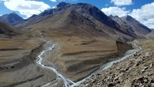 We could manage a truck to carry us to Mudh, a typical Spitian village after crossing a gushing tributary, Pagla Nala.
 Mudh is a picture-postcard worthy village with whitewashed houses, peas and barley terraced fields. Changing the tastes with delicious lunch, we drove to Kaza. There was nothing much to do apart from enjoying and grabbing the landscape of the vistas – barren, colourful mountains and what not in the camera. As we moved forward having the Spiti river alongside the highway, the view started to widen up more and more.
Kaza connects to Manali via Rohtang Pass by a few buses of Himachal transport. Those leave Kaza before the cock crows. Otherwise, there are few more options to avail like small cars that take almost a drive of twelve hours.
<!——
Pin Parvati Pass trek Himachal Himalaya trek Himachal trek
—–>