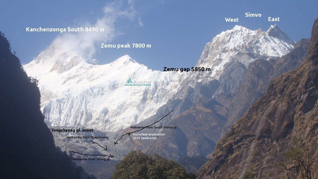
The electoral district of Dzongu in remote North Sikkim is inhabited by the indigenous Lepcha people. It’s geographic boundary to the west is marked by Talung(7350 m) and Pandim(6691 m) peaks. To the north by mt. Kangchenzonga South(8476 m), mt. Zemu peak(7780 m), Zemu Gap(5870 m) , mt. Simvu(6811 m) , mt. Sinioulchu(6888 m) , Kishong la pass(4785 m) and mt. Lamo Angdong(5900 m). To the east by Teesta river and to the south by Narsingh(5800 m) group of peaks. The valley constitutes the remotest reaches of the rich and varied Kanchenjonga Biosphere Reserve, an UNESCO world heritage site.
-
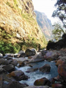
- The massive wall of ice and rock defining the northern boundery of Dzongu
Lepcha villages are thinly populated, always quiet ,and often wrapped up in a lively green cloak of vegetation. They worship nature whose care and protection are integral part of their philosophy. Many Lepcha has worked in fields of Butterflying, Birding etc ; Experts on Rhododendrons, master of bush craft can be found in these villages.
In this article I shall narrate only the nature and geographic setting of Dzongu valley, and touch upon the prospect of trekking.
Outline
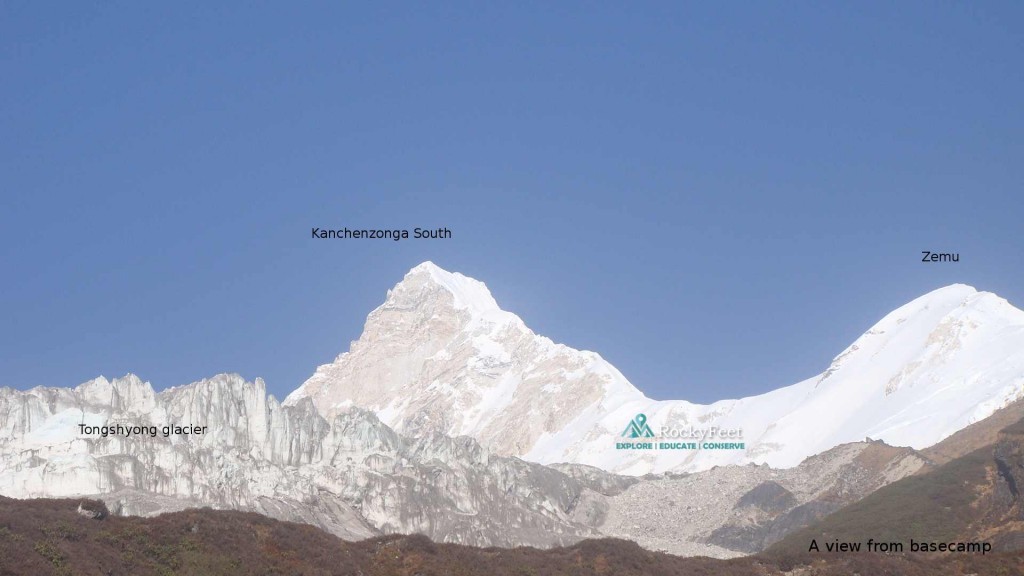
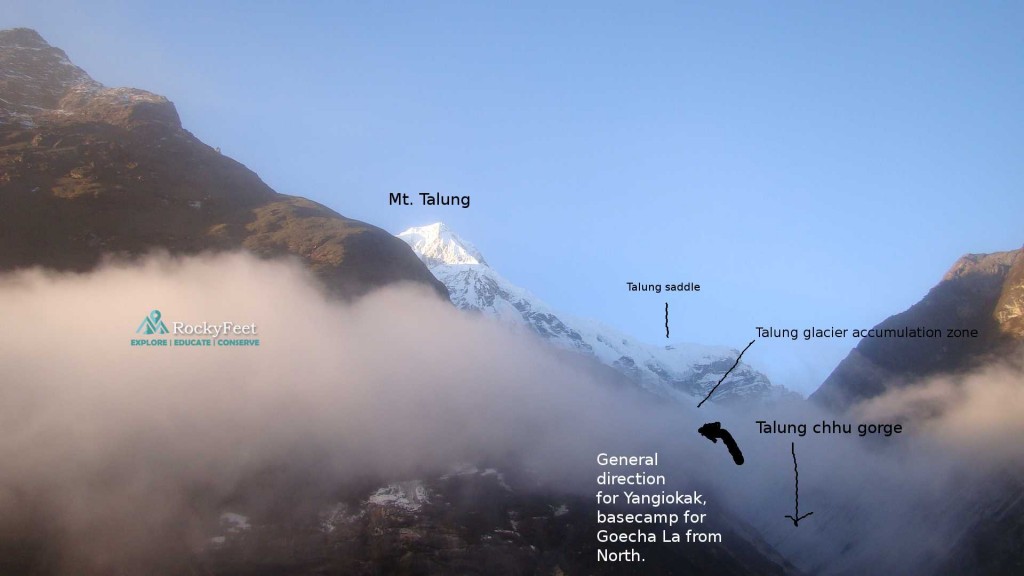
At the North-western corner of Dzongu region, Mount Talung lies on the main/parent ridge of the Kangchenzonga Himal. To the north of Talung lies mount Kangchenzonga south. Altitude of the ridge, around here, reaches its pinnacle. As the moisture laden, warm air from southern lowlands sweep in, they gradually gain elevation and cool down. At these extreme altitudes, they form ice crystals causing heavy snowfall year round. The eastern side of the enormous main ridge where lies east faces of both these peaks, acts as a gigantic catchment area for ice and snow. This massive amount of snow that these faces accumulate, slides down the mountain slope in the form of valley glaciers stretching south east.
-
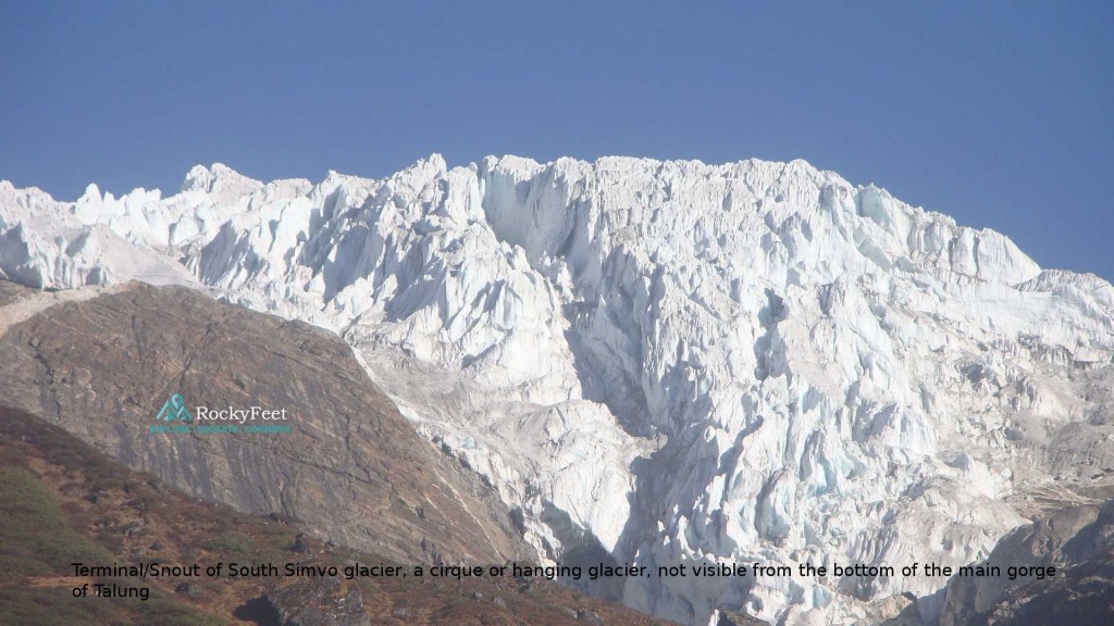
- The long hidden South Simvu glacier.
While the east face of mount Talung feeds Talung glacier with tons of snow, the south face of Kangchenjonga South feeds Tongshyong glacier. These two glacier’s watercourses named Talung chhu and Tongshyong chhu meets below tree line at around 4000 meters to form Rukel chhu. Immediately below, south Simvu glacier’s watercourse comes down from north and joins Rukel chhu. Rukel chhu flows south east for about 20 kms where it meets Rongyang chhu which comes down from the Jorpetam area east of Pandim. Rukel-Rongyang chhu combined watercourse then flows east from here. In its course,before meeting Teesta near Singhik,it is tributed by Passamram chhu and Umaram chhu from remote Jumthul Phuk-Kishong la-Lamo Angdong area. The whole river system is known as Talung river, after its main source. Talung river system is also known as the ‘other’ source of Teesta, even though its geographical attributes indicate an independent river system.
-
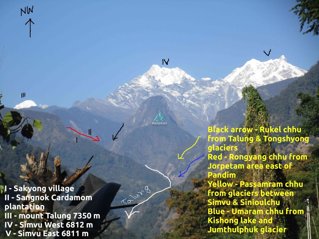
- Talung river system with a bird’s eye view of the valley
The valley
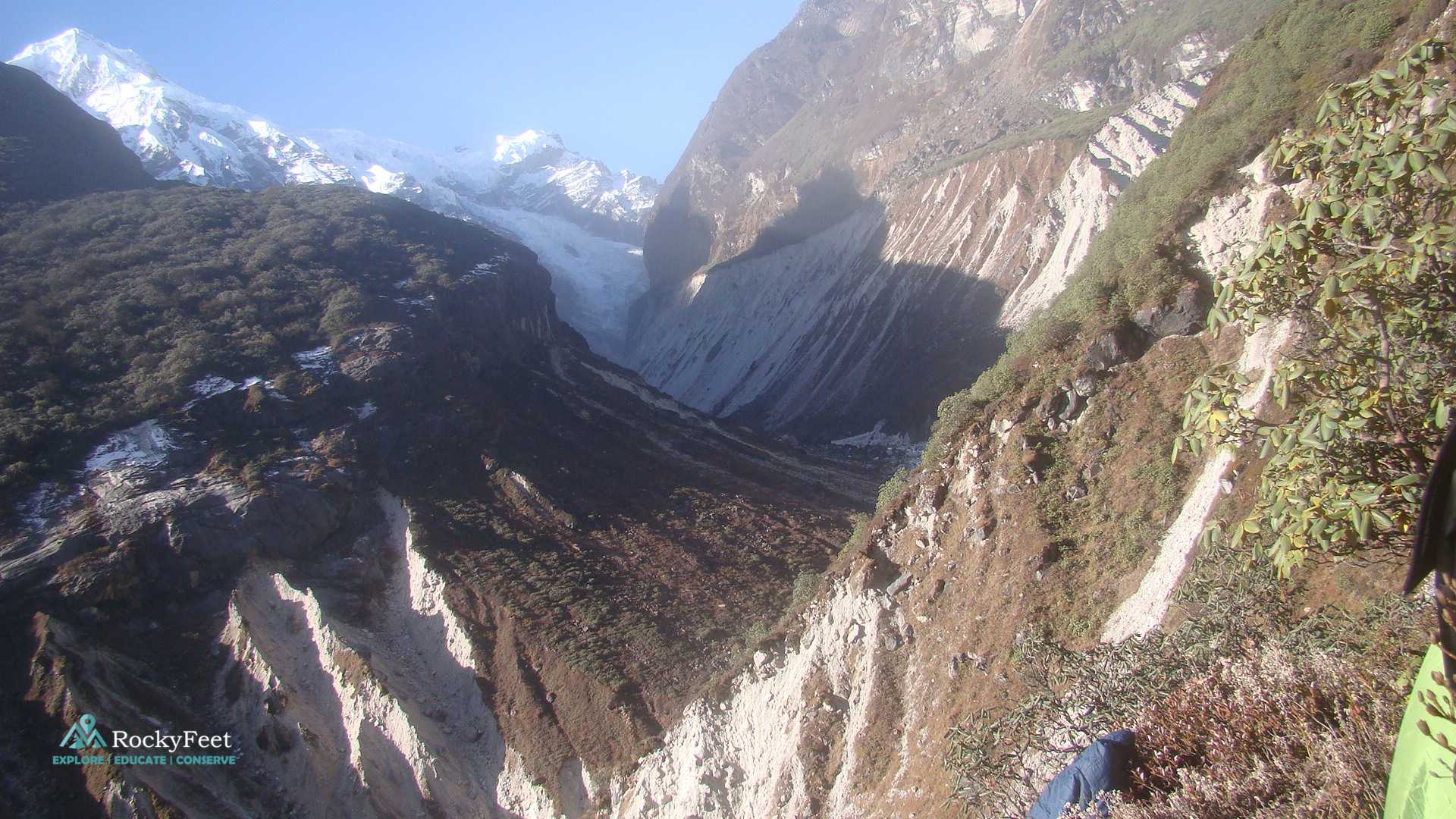
At the bottom of a glacier where the melt water sees its first daylight, called a snout. Snout of the Himalayan glaciers are continuously retreating deeper and higher into the mountains as the planet’s average temperature increases. This leaves long stretches of newly formed riverine valleys with eroded and unstable terminal moraines. The tree line is continuously pushed higher in the process.
-
- Looking north-west from Rukel chhhu valley. Snout of Tongshyong glacier is clearly seen.
The old glaciated valley of Rukel chhu is one such valley, and is rarely visited by cattle or human. It hides a multitude of animal and plants life at its core, and as you climb higher, it unveils a host of unclimbed peaks in a backdrop of an expansive South Kanchenzonga. The rocky peaks and ridge lines displaying rock formations like arete, rib, genderm form the walls of the gorge. Surrounded by sheer and precipitous cliffs, the rugged terrain is often challenging to negotiate. Impenetrable, thick, ancient forests of dwarf Rhododendron have forced the frail trail to hang precariously above the gushing torrent. These sections are barren, dusty and landslide prone. Massive water force of Rukel chhu keeps washing away the debri from bottom, causing imbalance and slides.
In places the river flows through deep narrow continuous cracks on the rock, disappearing altogether from the view. Sound of roaring water and the misty wet air gives away presence of the river. In places the narrow crack opens up and bare oily looking black rock walls get exposed. The trail in these areas remains always wet and muddy from the everlasting fine rain due to the cascading river’s profusion of mist.
-
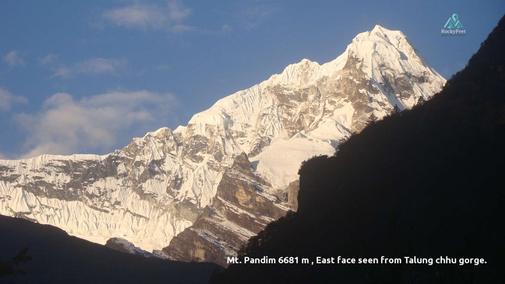
- A view full of hope, illuminated by evenning light. Mount Pandim seen from the deep damp stretch of the gorge, sun rays struggle all day to reach its bottom.
At around 3500 meters the dwarf rhododendrons thin out, conifers flourish. As the elevation farther decreases, dwarf Bamboo along with other seasonal grasses and weeds appear. The Bamboo covers huge areas on the mountainous slopes. The thickets of bamboo are ideal places to disorient a human altogether. Cutting through the thickets is only way possible to make progress, however the job is exhausting and progress remains generally slow. Even during the driest of months one can expect to advance for only about 5/6 kms per day by cutting through the treacherous mountain jungles. If route is lost, which can happen quite often, going gets even slower. The vegetation is thick, rocks so devoid of any hold that the trail climbs through living trees, roots, bamboos and dead logs. Rotten remains of temporary ladders can be found in certain steep sections which the local Lepcha bushmen/hunters place for their own purpose.
-
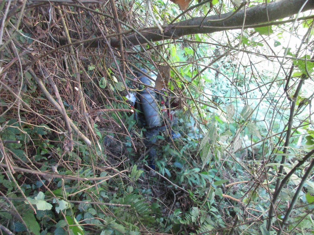
- Cut and squeeze through the jungle. This exhausting work continues for days. It gets worse as the bamboo thickets appear
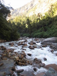
Lower down the valley , Rukel chhu river is joined by Rongyang chhu. Rongyang chhu gorge is a steep, lush green, virgin valley with huge mass of white water gushing down through it. It drains the area east of Pandim, Tinchenkhang and north of Narsingh. The combined watercourse now changes its south-easterly direction and flows east. The river gorge here is damp and densely vegetated. Series of rock in heaps, moist and slippery from the continuous mist, lie by the raging stream. Above, steep overhanging rock walls with thick cover of creepers and roots, guard the gorge. The bottom of the gorge gets exposed to sun’s rays for only a few hours. The sun always hits the northern hemisphere at an angle from south; as a result, southern bank of the gorge sees even less daylight, for 1/2 an hour to 1 hour per day, while the northern side gets 3-4 hours of sun. As the elevation decreases the dampness and density of the jungle increases. From both sides numerous streams and rivulets come down and join the main watercourse. Route finding, Unstable slippery dead logs, holes in the rocks hidden by thick cover of moss and fern, rotten and easy-to-snap roots, deadly slippery rocks at the river are the main obstacles.
-
- Pristine Talung gorge serves as a route
-
- Typical route along the slippery rocks of river.
Farther down, the cardamom plantations of Sangnok, are situated on the steep and vast slopes of Rukel chhu, overlooking the entrance to Passanran chhu to the north. From here the trail is better, although ladder climbing and nerve wrecking swinging bridges need to be negotiated. As the first village Sakyong comes in view, so does it’s sister village Pentong on the other side of the ever-widening gorge. Metal road starts from Pentong, goes through a huge landslide zone and Lingzya, Passamdem and other small hamlets , while following the Talung chhu to Mangan, the main town in the region. From Sakyong, its a 10 km easy walk till the metal road near Lingzya. In between Pentong and Lingzya, a route comes down from north, following Umaram chhu or Tholung chhu. Tholung gompa can be accessed through this route. This is the route for Kishong la near Lamo Angdong, and Zumthulphuk glacier near Sinioulchu.
Plants
Eastern Himalayan temperate forest flourishes on the lower reaches of the gorge between 1500 to 3000 meters. Bamboo is one of the main plants around here. Oaks, Rhododendrons along with Magnolia, Cinnamomum and Machilus of different species grow. Beyond 3000 meters Sub-alpine coniferous forests appear. Fir,Larch,Spruce,Birch,Maple and Pines are the most numerous. Here, dwarf rhododendrons start to grow. At 4000 meters conifers abruptly cease to exist. Alpine Shrub and Meadows appear. Dwarf rhododendrons of numerous species, Juniper bushes in profusion, other thorny bushes of berries and patches of grasslands exist here. Higher still, plant life exists. Up to 4700-4900 meters depending upon the direction of the slope, a few species of Rhododendrons and grass can be seen. Up in the Tundra zone, up to about 5500 meters elevations Tussock, Cushion plants, Lichens can be found.
Animals
The thick, virgin and remote forested valley hosts a rich animal life.
Birds of different plumage and families call the forest home. Different species of Laughingthrushes, Blackbirds, Tits, Shrikes, Magpies , Bushchats, Flaycatchers , Niltavas , Robins, Thrushes, Sibea, Dippers, Redstarts, Woodpeckers ,Parakeets thrive here. The high walls of the gorge provides the Himalayan Griffon vultures sanctuary. Golden Eagles soar high in higher altitudes riding the columns of hot air. Pheasants and Tragopans are found in Alpine Shrub lands along with Fulvetta, Partridge, Trogon and Derby’s parakeets. In alpine Meadows, Red and Yellow billed Chuff, Tibetan Snow Cocks , Snow Pigeon are found.
Among the mammals – Civets, Weasels, Marten, Macaques, Langurs, Porcupine, Wild boars, Himalayan Black Bear, Indian Leopard, Clouded leopard, Indian Wild dogs, Goral, barking deer, musk deer are found in the temperate zone. Serow, an increasingly endangered goat-antilope are found here in good numbers. Red Panda,the critically endangered flagship species of Sikkim lives in these undisturbed virgin corners of north Sikkim. They live between 2500 to 4000 meters in Bamboo forest mixed with conifers. The rock cliffs and slopes between 4000 to 6000 meters is layer of the elusive Snow Leopard. Himalayan Tahr,a wild mountain goat is found between 2500 to 5000 meters. The wild mountain sheep or Blueship or Bharal is also found at these altitudes. Both Tahr and Bharal are Snow leopard’s main prey.
Other carnivores at these altitudes are Himalayan Brown Bear, Himalayan Wolf and a host of different species of raptors.
-
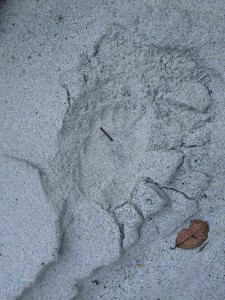
- Fresh pug mark of a Himalayan Black Bear
-
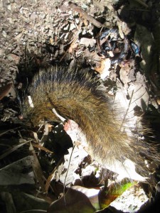
- Tail of an Irawaddy squirrel, probably preyed on by some predator
-
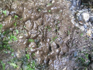
- Pug mark of Indian wild dog OR Himalayan Wolf. Could not be confirmed
Scope of Exploration
The virgin land has to offer magical spectacles ,scope of discovery and adventures that are unique. Question is , are we responsible enough to send out expedition teams in such a manner and discipline which ensures that ecological balance remains intact? Are we that strong and dogged to carry out long and exhausting exploration without compromising nature and natural life? If answer to both the questions is an honest “yes”, then proceed, go ahead and explore. Dzongu has kept hidden the secrets of virgin forest and complex glaciated amphitheatre of unclimbed peaks which she’ll only give away to the determined explorer.
There are literally no end of exploration opportunities in the valley. Almost all the routes are minimally used by human. Definitely come prepared with your proper fitness, rationing, maps, equipments like ropes, at least 2 sicle/chapati for cutting undergrowth and bamboo thickets. Rationing should be done keeping additional back up as slow progress through the trail is expected. Local/chineese Gum-boots are ideal until you reach the glaciers. Rubber/Vibram soles of standard trekking shoes may fail while climbing the very long stretches of wet,slippery mud and rock sections. Proper knowledge of first aid and a good kit is must.
A local guide, usually a Lepcha, must be hired. Route finding is going to be a key activity.
The good news
Our exploration in this region is ongoing. We will be happy to guide you with our expertise or organise trek for you. Reach us to know more about the different possible routes here.


Very well Written. I can connect even Better Now.
You are the first reader of the blog who have been to the region. Those who haven’t entered Dzongu yet, cant have much clue , such is the land